
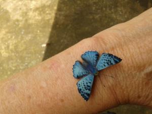
Occurrence record: Observations:10220764
HumanObservation
of
Caruya
recorded on 2018-02-13
Images
Dataset
| Data resource | dr858 |
| institutionCode | Supplied institution code "iNaturalist" |
| collectionCode | Supplied collection code "Observations" |
| catalogNumber | 10220764 |
| occurrenceID | 10220764 |
| basisOfRecord |
Human observation
Supplied basis "HUMAN_OBSERVATION" |
| identifiedBy | Luiz M. R. Gadelha Jr. |
| Identified date | 2018-03-13T19:37:57 |
| Collector | Luiz M. R. Gadelha Jr. |
| License | CC-BY-NC 4.0 (Int) Supplied as CC_BY_NC_4_0 |
| Rightsholder | Luiz M. R. Gadelha Jr. |
| datasetName | iNaturalist research-grade observations |
| occurrenceStatus | present Supplied as PRESENT |
| Abcd identification qualifier | Not provided |
| dateIdentified | 2018-03-13 Supplied as 2018-03-13T19:37:57 |
| identificationID | 22676140 |
Event
| Occurrence date |
2018-02-13
Supplied date "2018-02-13T00:00:00" |
| Date precision | Day |
| verbatimEventDate | 2018/02/13 2:18 PM -02 |
Taxonomy
| scientificName |
Caruya
Supplied scientific name "Riodinidae" |
| taxonRank |
genus
Supplied as "FAMILY" |
| Kingdom | Animalia |
| Phylum | Arthropoda |
| class | Insecta |
| Order |
Hemiptera
Supplied as "Lepidoptera" |
| Family |
Cicadellidae
Supplied as "Riodinidae" |
| Genus | Caruya |
| Taxonomic issue | No issues |
| Name match metric |
Taxon GUID match
The match was based on the supplied taxon concept ID rather than the scientific name. |
| acceptedNameUsageID | 1933999 |
| taxonomicStatus | ACCEPTED |
Geospatial
| Country | Brasil |
| State or Territory | Minas Gerais |
| decimalLatitude | -21.226344 |
| decimalLongitude | -43.062246 |
| geodeticDatum | EPSG:4326 |
| verbatimLocality | Piraúba - State of Minas Gerais, 36170-000, Brazil |
| coordinatePrecision | Unknown |
| coordinateUncertaintyInMeters | 13.0 |
| continent | SOUTH_AMERICA |
| countryCode | BR |
Additional properties
| accepted scientific name | Riodinidae |
| accepted taxon key | 1933999 |
| class key | 216 |
| dataset key | 50c9509d-22c7-4a22-a47d-8c48425ef4a7 |
| family key | 1933999 |
| gbif id | 1836625502 |
| generic name | Riodinidae |
| has coordinate | true |
| has geospatial issues | false |
| iucn red list category | NE |
| kingdom key | 1 |
| last crawled | 2023-01-30T09:54:40.069Z |
| last interpreted | 2023-01-30T15:11:30.918Z |
| last parsed | 2023-01-30T15:11:30.918Z |
| level0gid | BRA |
| level0name | Brazil |
| level1gid | BRA.13_1 |
| level1name | Minas Gerais |
| level2gid | BRA.13.601_2 |
| level2name | Piraúba |
| media type | StillImage |
| order key | 797 |
| phylum key | 54 |
| protocol | DWC_ARCHIVE |
| publisher | iNaturalist.org |
| publishing country | US |
| references | https://www.inaturalist.org/observations/10220764 |
| repatriated | true |
| taxon key | 1933999 |
| verbatim scientific name | Lasaia agesilas |
Data quality tests
| Test name | Result |
| Name not in national checklists | Warning |
| Geodetic datum assumed WGS84 | Warning |
| Country inferred from coordinates | Warning |
| Show/Hide 29 passed properties | |
| Show/Hide 8 missing properties | |
| Show/Hide 46 tests that have not been run | |

