
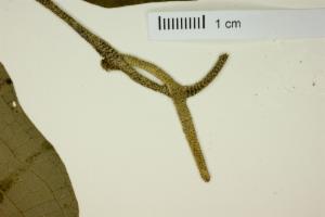
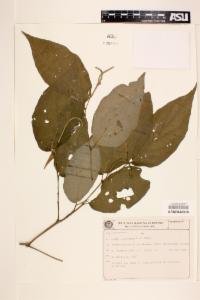
Occurrence record: Plants:ASU0044516
Specimen
of
Piper dilatatum
recorded on 1987-12-29
Images
Rights: http://creativecommons.org/licenses/by-nc/3.0/
Rights holder: Arizona State University Vascular Plant Herbarium (ASU-Plants)
Image license: http://creativecommons.org/licenses/by-nc/3.0/
View image details
Rights: http://creativecommons.org/licenses/by-nc/3.0/
Rights holder: Arizona State University Vascular Plant Herbarium (ASU-Plants)
Image license: http://creativecommons.org/licenses/by-nc/3.0/
View image details
Dataset
| Data partner | Dados repatriados Portal GBIF - ocorrência no Brasil |
| Data resource | GBIF repatriados | Arizona State University | Vascular Plant Herbarium | CC BY 4.0 License |
| institutionCode | Supplied institution code "ASU" |
| collectionCode | Supplied collection code "Plants" |
| catalogNumber | ASU0044516 |
| otherCatalogNumbers | 195624 |
| occurrenceID | 1961188 |
| basisOfRecord |
Preserved specimen
Supplied basis "PRESERVED_SPECIMEN" |
| identifiedBy | R. Callejas |
| Identified date | 1991-01-01T00:00:00 |
| Collector |
Kummrow, R.|Cordeiro, J.
Supplied as "R. Kummrow; J. Cordeiro" |
| recordNumber | 2965 |
| Rights | http://creativecommons.org/licenses/by-nc/3.0/ |
| License | CC-BY 4.0 (Int) Supplied as CC_BY_4_0 |
| collectionID | a2e32c87-d320-4a01-bafd-a9182ae2e191 |
| occurrenceRemarks | Arbusto ca. 2,50 m. |
| occurrenceStatus | present Supplied as PRESENT |
| Abcd identification qualifier | Not provided |
| dateIdentified | 1991-01-01 Supplied as 1991-01-01T00:00:00 |
Event
| Occurrence date |
1987-12-29
Supplied date "1987-12-29T00:00:00" |
| Date precision | Day |
| startDayOfYear | 363 |
Taxonomy
| higherClassification | Plantae|Spermatophyta|Tracheophyta|Magnoliophyta|Magnoliids|Piperales|Piperaceae|Piper |
| scientificName |
Piper dilatatum
Supplied scientific name "Piper dilatatum Rich." |
| taxonRank | species |
| Kingdom | Plantae |
| Phylum | Tracheophyta |
| class | Magnoliopsida |
| Order | Piperales |
| Family | Piperaceae |
| Genus | Piper |
| Species | Piper dilatatum |
| Taxonomic issue | No issues |
| Name match metric |
Exact match
The supplied name matched the name exactly. |
| Name parse type | SCIENTIFIC |
| taxonomicStatus | ACCEPTED |
Geospatial
| Country | Brasil |
| State or Territory | Parana |
| locality | Pedra Branca de Araraquara (mun. Guaratuba). |
| habitat | Mata pluvial da vertente atlântica. |
| decimalLatitude | -25.9 |
| decimalLongitude | -48.5667 |
| geodeticDatum | EPSG:4326 |
| coordinatePrecision | Unknown |
| coordinateUncertaintyInMeters | 30000.0 |
| georeferenceVerificationStatus | reviewed - high confidence |
| georeferenceSources | T&CW |
| georeferencedBy | alorozco |
| continent | SOUTH_AMERICA |
| countryCode | BR |
Additional properties
| accepted scientific name | Piper dilatatum Rich. |
| accepted taxon key | 3086349 |
| class key | 220 |
| dataset key | e05fd4c2-4d77-4c50-880e-1b22096af300 |
| family key | 6678 |
| gbif id | 2270523076 |
| generic name | Piper |
| genus key | 3075433 |
| has coordinate | true |
| has geospatial issues | false |
| iucn red list category | LC |
| kingdom key | 6 |
| last crawled | 2023-07-01T02:08:44.383Z |
| last interpreted | 2023-07-01T02:28:34.488Z |
| last parsed | 2023-07-01T02:28:34.488Z |
| level0gid | BRA |
| level0name | Brazil |
| level1gid | BRA.16_1 |
| level1name | Paraná |
| level2gid | BRA.16.139_2 |
| level2name | Guaratuba |
| media type | StillImage |
| order key | 404 |
| phylum key | 7707728 |
| protocol | DWC_ARCHIVE |
| publishing country | US |
| references | https://swbiodiversity.org/seinet/collections/individual/index.php?occid=1961188 |
| repatriated | true |
| species key | 3086349 |
| taxon key | 3086349 |
| verbatim scientific name | Piper dilatatum |
Data quality tests
| Test name | Result |
| Name not in national checklists | Warning |
| Geodetic datum assumed WGS84 | Warning |
| Country inferred from coordinates | Warning |
| Show/Hide 32 passed properties | |
| Show/Hide 5 missing properties | |
| Show/Hide 46 tests that have not been run | |
Additional political boundaries information
| ANA | Divisão Hidrográfica Nacional - Macro Região Hidrográfica | ATLANTICO SUL |
| ANA | Divisão Hidrográfica Nacional - Meso Região Hidrográfica | Litoral do Parana e Santa Catarina |
| ANA | Divisão Hidrográfica Nacional - Micro Região Hidrográfica | Litoral do Parana |
| IBGE | Biomas do Brasil (2022) | Mata Atlantica |
| IBGE | Domínios morfoestruturais do Brasil (2021) | Depositos Sedimentares Quaternarios |
| IBGE | Estados do Brasil | Parana |
| IBGE | Folhas da Carta Internacional do Mundo, ao Milionésimo (IBGE) | Parana |
| IBGE | Folhas da Carta Internacional do Mundo, ao Milionésimo (IBGE) | Paraná |
| IBGE | Limite do Bioma Mata Atlântica (2022) | Mata Atlantica |
| IBGE | Limite do Brasil | 1 |
| IBGE | Municípios do Brasil (2022) | Guaratuba |
| IBGE | Pedologia do Brasil (2021) | AREA URBANA |
| IBGE | Regiões do Brasil | Sul |
| Limite da Zona Costeira e Marinha | Massa Dagua Costeira - Mar Territorial, 12 milhas |
| Municípios do Brasil | GUARATUBA |
| WWF | Ecorregiões de Água Doce (2008) | 331 |
| WWF | Ecorregiões marinhas mundiais (2007) | Southeastern Brazil |

